 The State of Water in the Gulf Coast

Coastal wetlands support 60%-90% of the commercial fisheries in the U.S. Saltwater fishing in Texas generates $2 billion annually.
Major Water Challenge: “Freshwater inflow” Competing demands for water upriver from bays and estuaries prevents freshwater from flowing into the bays and estuaries and mixing with saltwater, thus affecting the salinity of these areas and the ability of young species to survive.
Water Resource Problems: By 2050, this population is expected to more than double; municipal and manufacturing needs will increase. Additional water sources will be needed.
Water Planning Areas: N, P, H, I, M, L, K online map
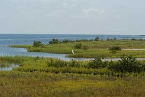
The Gulf Coast region is a nearly-level plain, dissected by streams and rivers flowing into the Gulf of Mexico. The 21,000 square mile region includes barrier islands along the coast, salt grass marshes surrounding bays and estuaries, remnant tallgrass prairies, oak parklands and oak mottes scattered along the coast and tall woodlands in the river bottomlands. Soils are acidic sands and sandy loams, with clays occurring primarily in the river bottoms.
Coastal wetland habitats contain the largest diversity of plants and animals of any Texas aquatic ecosystem. This is due in large part to the diversity of habitats that make up coastal wetlands.
Gulf Coast wetlands are mostly flat and defined by their mix of salty and fresh water although sometimes the water is entirely fresh. Potholes, wet prairies and forested wetlands are found just inland from the tidal zone. Tidal wetlands include barrier islands, tidal flats, bays, estuaries and bayous. Coastal wetlands provide habitat for millions of migrating waterfowl and protection from storms that erode the shoreline. Bays and estuaries are nursery and spawning areas for marine species and habitat for oysters and clams that filter tons of pollutants out of gulf coast waters.
 The success of these wetlands depends upon having the right amount of freshwater flowing in to the saltwater. Most major Texas rivers flow to coastal estuaries, and it is through these rivers and streams that the flow of freshwater helps maintain a fragile balance of water chemistry that sustains many specially-adapted plants and animals. These areas are the nurseries for many saltwater fish, crabs, shrimp and shellfish. Their importance can’t be overstated.
In addition to aquatic species, coastal wetlands also support a diversity of bird life such as shore birds, wading birds, gulls, terns and pelicans. Songbirds migrating in the spring often travel great distances across the Gulf of Mexico before landing safely on Texas shores. Sadly, coastal wetland habitats are being destroyed at an alarming rate as a result of development, decreases in water quality and other threats. Communities and resource professionals are teaming up to conserve these productive habitats.
The Gulf waters range from beachfront to offshore environments with depths varying from 1 or 2 feet for the beachfront to depths of over 100 feet offshore. The beachfront contains fine shell deposits and sandbars. In the bays, water is salty, but fairly shallow, with seagrass beds providing important cover for fish, crabs, shrimp and shellfish. Sand bars, spoil island and shell reefs also provide structure. Several species of crustaceans, jellyfish, sea turtles and others inhabit inshore and offshore waters supplying food for fish and others of their kind.
Water Supply and Demand
Supply
Major River: San Jacinto, Trinity, Brazos, Nueces, San Antonio
Major Aquifer: Gulf Coast, Carrizo-Wilcox
Use & Demand
Mid-North Coast: 67% demand met through surface water. 36% demand is municipal, 35% manufacturing, 23% for irrigation.
By 2050, the population of the area is expected to double. The demand for water is expected to change to 50% for irrigation, and 44% for municipal needs.
South Coast: 75% demand met through surface water. 49% for municipal needs; 30% manufacturing.
By 2050, demand expected to change to 54% municipal, 37% manufacturing.
Water supplies may be insufficient to meet demand. (Source: Texas Center for Policy Studies. Texas Environmental Almanac (Austin: U.T. Press, 2002), 24-29.)
Major Cities / Rainfall / Elevation
Regional Average Rainfall - Mid-North: 40-60 in./yr
Regional Average Net Evaporation rate: 16-28 inches
Data source: National Climate Data Center, U.S. Dept of Commerce.
Alvin - 51.73 in. / 28 ft.
Baytown - 53.75 in. / 34 ft.
Beaumont - 57.38 in. / 27 ft.
Corpus Christi - 32.26 in. / 41 ft.
Galveston - 43.84 in. / 10 ft.
Houston - 47.84 in. / 95 ft.
Port Arthur - 59.89 in. / 16 ft.
Port Isabel - 28.56 in. / 17 ft.
Raymondville - 27.97 in. / 31 ft.
Sugarland - 49.34 in. / 82 ft.
Victoria - 40.10 in. / 115 ft.
Wharton - 45.62 in. / 111 ft.
