 The State of Water in the Panhandle Plains
The Ogallala Aquifer lies under 4 states, and in Texas, under the Panhandle Plains. It is the primary water source for millions of people. It also provides irrigation water for the agriculture on which much of Texas and nation depend. Water is being pumped from the Ogallala faster than it can recharge.
Major Water Challenge: Managing groundwater in a right of capture* state
Water Resource Problems: Scarce surface water (i.e. rivers, lakes, streams); decreasing groundwater and aquifer
Water Planning Areas: A, O, F, G, B, C online map
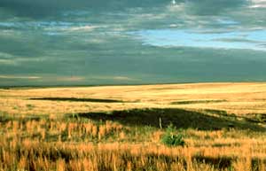
Located in northwest Texas, the High Plains and Rolling Plains of the Panhandle form the southern end of the Great Plains of the central United States. The landscape varies from gently rolling to brushy, rough and dissected with canyons. The legacy of the Old West stands amid the rainbow-hued canyons of the Caprock Escarpment carved by the headwater tributaries of the Red River.
The Panhandle Plains are part of an ecological region of international significance. Scattered across the southern high plains of Texas, New Mexico, Kansas, Oklahoma and Colorado are more than 25,000 playa lakes -- havens for wildlife and people.
Playas are simple depressions in a prairie or plain where rainwater collects. In ancient times, bison used these wetlands as watering holes and wallows and the Native American tribes who followed the bison found good hunting, water and many edible plants nearby. Today, farmers often plant grain crops like wheat or corn around playas, which provide feeding, wintering and breeding areas for ducks, geese and other migratory birds.
Most playas are seasonally flooded basins. In good years, these shallow basins collect about three or four feet of water. Over time, the moisture either evaporates or filters through the soil to recharge the aquifer.
Playas provide the most significant wetland habitats in the southern quarter of the Central Flyway for migrating and wintering birds. Up to two million ducks and hundreds of thousands of geese take winter refuge here. Shorebirds, wading birds, game birds, hawks and owls, and a variety of mammals also find food and shelter in playas.
Playas, left in their natural condition, harbor the greatest variety of plant species and produce the most invertebrates, which are important food sources for waterfowl. Spring and summer rains determine how much natural food will be available to ducks and geese in the wintertime. Waterfowl feed on the seed of aquatic plants such as smartweed and dock. They also feed heavily on waste corn in farm fields.
The Panhandle is home to several rivers. Riparian wetlands occur along banks of creeks, rivers and lakes. In an otherwise open prairie, riparian wetlands provide food and cover for many birds and animals.
Water Supply and Demand
Supply
Major Rivers: Red, Pecos, Canadian, Colorado and Brazos
Major Aquifer: Ogallala, Seymour, Cenozoic Pecos Alluvium, Edwards-Trinity
Use & Demand
- 97% of this area’s water needs are dependent upon the Ogallala Aquifer*.
- Approximately 90% of the water demand is for irrigation.
- Groundwater has high fluoride, arsenic and nitrate levels and has been contaminated by abandoned oil fields. (Source: Texas Center for Policy Studies. Texas Environmental Almanac (Austin: U.T. Press, 2002), 20.)
Major Cities / Rainfall / Elevation
Regional Average Rainfall: 15-28 in./yr
Data source: National Climate Data Center, U.S. Dept of Commerce.
Abilene - 23.78 in / 1,790 ft
Amarillo - 19.716 in / 3,586 ft
Borger - 21.984 in / 3,140 ft
Boys Ranch - 18.18 in / 3,191 ft
Brownwood - 28.32 in / 1,385 ft
Clarendon - 23.89 in / 2,700 ft
Lamesa - 19.07 in / 2,965 ft
Lubbock - 18.69 in / 3,254 ft
Memphis - 22.51 in / 2,090 ft
Midland - 14.80 in. / 2,862 ft
Muleshoe - 17.37 in / 3,825 ft
Paducah - 24.11 in / 1,900 ft
Perryton - -20.88 in / 2,942 ft
Right of Capture -- the right of landowners to pump water underneath their property without malice or consideration for the water supply for neighboring wells.